


Three tools. A spectacular geological location with rich biodiversity and high levels of fishing activities. And a littered beach. What could a variety of mapped data tell us about lost fishing gear and littering? We dived into three public mapping tools to look around the shoreline of Andøya and Bleiksdjupet.
Since its foundation in 2018, the Norwegian Centre against Marine Litter has been developing tools for the clean-up of marine litter and collection of data relating to marine litter from relevant stakeholders in a single place. This place has become the digital tool Rent hav, which has been developed for anyone working with marine litter in Norway. Data from inspections, clean-up operations and observations is registered in Rent hav and is also used as the database for what clean-up volunteers register in Rydde.
Experiences from an inlet
The coastline running from Andenes and past Bleik in the northernmost part of Andøya is known for its beautiful beaches and rugged mountains. Several clean-up operations have been carried out on these beaches between 2016 and now and the data from these operations has been collected using Rent hav. In 2021, the Norwegian Retailers’ Environment Fund project Rydd Norge launched a large-scale clean-up operation of the shoreline on Andøya. One of the clean-up zones, an inlet called Rekvika, lived up to its name. Rekvika was an extremely littered area and the clean-up activities there were challenging, as was access for the clean-up operator LoveMar, which stated the following in its report on the operation:
Around 40 cubic metres of marine litter were found in Rekvika. Insane amounts! The litter primarily consisted of plastic and the majority originated from the fishing industry, with some originating from aquaculture.
The clean-up operation in Rekvika told a similar story about littering as the data collected during the clean-up operations that had previously been carried along the shoreline on Andøya. A lot of the litter originated from the fishing industry. The plastic was porous and close to disintegrating under the weathered driftwood logs. This indicates that some of the litter had been there for a long time. In total, Rydd Norge collected 10 tonnes of marine litter in Rekvika.
FiskInfo – the fishermen’s tool on board
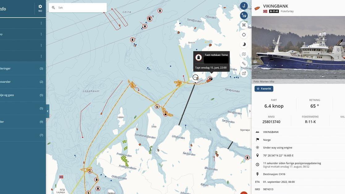
Barentswatch’s map solution, FiskInfo, is a service in which fishermen register the fishing gear they are using via the onboard map plotter. This enables FiskInfo to provide fishermen and everyone else with access to data about where there are active nets, lines, fishpots and similar fishing gear in the water. This data sharing helps prevent loss and usage-related conflicts.

The “ghosts” shown on the map provide an overview of the extent of fishing gear that has been lost in Norwegian waters. FiskInfo also provides the Norwegian Directorate of Fisheries and the Norwegian Coast Guard with information about where to look for lost tools so that these can be removed when the fishermen have given up on their own search. Lost fishing gear does not necessarily equate to damaged fishing gear and will often be returned to the owner, who can use the fishing gear again.
Looking for ghosts
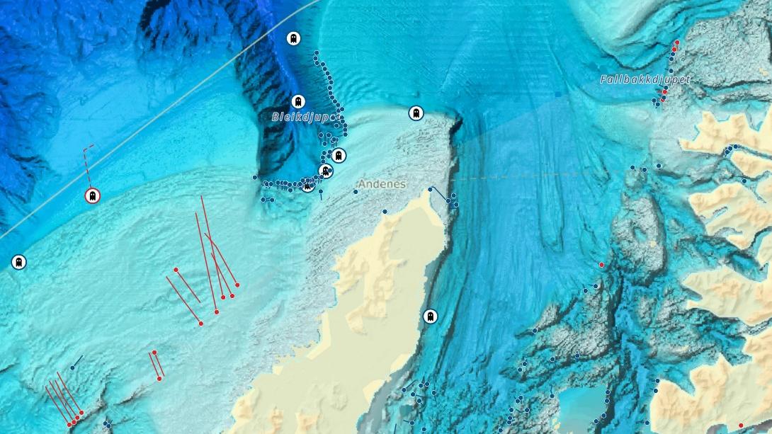
Since the 1980s, the Norwegian Directorate of Fisheries has conducted clean-up operations to remove lost fishing gear from the fishing fields along the coast. Since then, more than 1,000 tonnes of lost fishing gear has been removed from the seabed. The reason why the Norwegian administration facilitates the removal of lost fishing gear can be found in legislation. Pursuant to the Norwegian Pollution Control Act, losing fishing gear during active fishing is not prohibited, but it does give rise to some obligations. Fishermen need to look for any fishing gear they lose. If they are unable to find the fishing gear or if it is not possible for them to carry out a search, they have a duty to report the loss. The Norwegian Coast Guard will carry out a search if it has available resources. Otherwise, the next measure will be the annual clean-up operation arranged by the Norwegian Directorate of Fisheries. In 2022 alone, 1,128 nets of various types were removed. Nearly 60,000 metres of lines and rope were removed, as well as 204 fish pots. Fishing gear lost and removed between 2017 and now has been added as a separate map layer in the Norwegian Directorate of Fisheries’ map solution, Yggdrasil.
Ghost fishing is one of the most harmful forms of marine litter, as the lost fishing gear continues to do what it was designed to do, catch fish and seafood. In its action plan to combat marine litter, the Norwegian Directorate of Fisheries has introduced a number of initiatives relating to lost fishing gear and emphasis is placed on preventing the loss of fishing gear. In the future, ghost fishing in Norwegian waters may be so reduced as a result of legislation, labelling and effective systems that clean-up operations will become less necessary.

The preventive possibilities of the data ocean
The data collected by Rent hav provides information about sources and trends, which in turn can help explain where initiatives should be prioritised. FiskInfo is a map solution that helps prevent losses in itself by providing fishermen with information that can help prevent usage-related conflicts. The map service also provides an overview of the extent of lost fishing gear in Norwegian waters. This could help raise awareness of the issue and, over time, provide data about the locations with the greatest risk of loss, as well as the types of fishing gear that are most frequently lost.
Yggdrasil also shows that clean-up activities help make the ocean cleaner. The ocean of data collected through Rent hav, FiskInfo and Yggdrasil is not simply stored in a database, it is also made available through the map tools that display the data. This allows for new opportunities to view correlations that can be analysed, contributing to new knowledge or highlighting the need to collect more knowledge. The ocean of data also shows the correlation between activities and littering and helps raise awareness of the environmental problem that is marine litter. In addition, the map tools display data about fishing activities and natural assets, demonstrating the important resources in the waters off Andøya. In June 2022, the Norwegian Fishermen’s Association published its own action plan to combat marine litter. The plan shows that the industry considers marine litter to be a serious issue and their goal is to stop fishing-related plastic waste from ending up in the water.
This article is based on the talk “Management tools and actions increasing awareness and preventing lost fishing gear”,delivered by the Norwegian Centre against Marine Litter’s Ragnhild Nyland at 7IMDC in Busan, South Korea, in September 2022.
With thanks to LoveMar for the video and photographs used in the article.
A lot of the clean-up activities in Norway have been plotted on the map in Rent hav, together with useful information about the environment and activities along the coast. You can try out Rent hav with or without an account.